


The old Lagoon Pond drawbridge had a good run, but after seventy-five years it was more than a little cantankerous. Steel would expand under the summer sun and prevent it from fully closing. Old pilings had shifted, pushing things out of alignment. It was time.
So it came as no great surprise in 2003 when the state of Massachusetts, which owned the bridge, said it wanted to build a new one. Naturally, the Island’s default reaction was – not so fast. When external forces impose their will on the Vineyard, we end up with utility poles that seem to have been designed for the Jurassic period.
Such a situation called for only one thing: a committee. The Lagoon Pond Drawbridge Committee was formed under the auspices of the Martha’s Vineyard Commission and Melinda Loberg of Vineyard Haven was appointed chair. “In the beginning it was rocky,” she told me. “The state didn’t think much of us, and I guess we didn’t think much of them. We were probably a little naive about how long it takes bureaucracies to move.”
The state proposed a two-bridge solution: a temporary bridge would be built next to the old bridge, which would be taken down and replaced with the new bridge. The committee (not to mention the rest of the Island) couldn’t understand why the state wouldn’t just build the new bridge and use the old bridge until the permanent one was completed.
One problem was permitting. A new bridge in a new location would require a whole new set of federal, state, and local permits. It can take years to get a permit to build a dock; one can only imagine how long a drawbridge would take. The temporary bridge was exempt from this process.
But there was an even bigger obstacle. The state didn’t know if the existing bridge would last long enough to build the new one. “Plus, they weren’t going to continue to repair it anymore,” Loberg explained. “And if it broke it would have to be left open, because the Coast Guard owns the channel and boat traffic would have to come first. They had us over a barrel.”
All of this took place against a backdrop of the general -economic downturn and an escalating budget. Originally estimated to cost around $30 million, the total is now projected at $43.7 million, including the temporary bridge. At one point, the state generously offered to let the Island take over the project, relieving themselves of the financial burden. That idea went about as far as someone else’s suggestion to take the old ferry Islander and put it in place of the bridge, with the doors open at both ends so traffic could just drive through the boat to get to the other side of the channel.
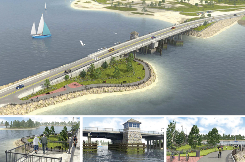
But back to reality. The temporary bridge went up and the old bridge came down in 2010. Ask not where the next few years went, but suffice it to say construction of the new bridge at last got underway in the fall. The first step was to sink a foundation of fifty-two pilings in the middle of the channel. A potential problem was that winter flounder spawning season runs from January 15 to May 31. Working in the water is prohibited during this period. The solution came in the form of a cofferdam.
A cofferdam is a steel cylinder that is built around the work area. It extends above the surface of the water and protects the environment outside of the work area. Once in place, the water is drained from the cofferdam, thereby providing a dry place to build the foundation.
As of now, the new bridge is scheduled to be drivable and ready for testing in May of 2015. The testing will run throughout the winter of 2016 and, knock on steel, the new bridge should be fully complete by the summer of 2016. There will, unfortunately, be some disruption to boat traffic while the temporary bridge is being dismantled.
“If the two bridges had moveable sections that lined up perfectly, they could co-exist,” Loberg explained. “But since we had to move the channel, the two bridges can’t open at the same time – they would hit.”
That means that in the fall of 2015, while the temporary bridge is being dismantled, larger boats won’t be able to enter or leave the Lagoon. It will be a big inconvenience for some, but plans are already being made to find alternative moorings.
Loberg is the first to admit that in the beginning there was a certain amount of head-butting between the state and the drawbridge committee.
“They came down ready for battle,” she recalls of the public comment hearing. “But as it turned out, there was a small crowd and the general comments were positive. Steve McLaughlin, [a Department of Transportation project manager], said, ‘Hey that was easy. Usually the whole community comes out with pitchforks, but they were friendly.’ And that was because our committee had already done the public hearings – we made it a lot easier for the state.”
One of the suggestions that the committee made that the state accepted was to build a park around the bridge. “It’ll be a lovely place,” said Loberg. “With bikeways, a fishing platform, a kayak landing, benches and trees – you’ll be able to walk right under the bridge.”
So that, in a nutshell, is how to build a drawbridge (or two), and it sounds like we’re going to have a fine one. But you have to admit: driving through the Islander to get across the channel – how cool is that?
